Chester city walls.jpg
From Warlike Expounder
File:Chester city walls.jpg
No higher resolution available.
Chester_city_walls.jpg (640 × 480 pixels, file size: 138 KB, MIME type: image/jpeg)
Summary
| Description |
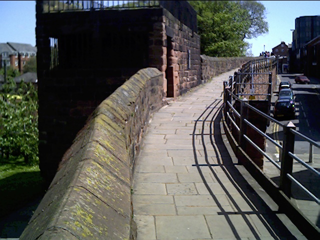
English: Morgan's Mount, City Walls, Chester Medieval Watch Tower/Gun Platform located on Chesters Walls to the West of Northgate. During the Civil War Captain Morgan was in charge of the Gun Position. The platform was damaged by cannon fire. And during the construction of the canal below several skeletons were found.
|
|
| Date | ||
| Source | From geograph.org.uk | |
| Author | chestertouristcom | |
| Attribution (required by the licence) | chestertouristcom / Morgan's Mount, City Walls, Chester / | |
| Camera location | | View this and other nearby images on: OpenStreetMap |
|---|
Licensing

|
This image was taken from the Geograph GB & Eire project collection. See this photograph's page on the Geograph website for the photographer's contact details. The copyright on this image is owned by chestertouristcom, and is licensed for reuse under the Creative Commons Attribution Share-Alike 2.0 license.
|
This file is licensed under the Creative Commons Attribution-Share Alike 2.0 Generic licence.
Attribution: chestertouristcom
- You are free:
- to share – to copy, distribute and transmit the work
- to remix – to adapt the work
- Under the following conditions:
- attribution – You must give appropriate credit, provide a link to the licence, and indicate if changes were made. You may do so in any reasonable manner, but not in any way that suggests the licensor endorses you or your use.
- share alike – If you remix, transform, or build upon the material, you must distribute your contributions under the same or compatible licence as the original.
File history
Click on a date/time to view the file as it appeared at that time.
| Date/Time | Thumbnail | Dimensions | User | Comment | |
|---|---|---|---|---|---|
| current | 18:04, 24 February 2009 | | 640 × 480 (138 KB) | wikimediacommons>Peter I. Vardy | {{Information |Description={{en|1=Photograph of Chester city walls showing Morgan's Mount}} |Source=http://www.geograph.org.uk/photo/10210 |Author=chestertouristcom |Date=14 May 2005 |Permission= |other_versions= }} {{geograph}} <!--{{ImageUpload|full}}-- |
File usage
The following page uses this file: